

 Please log in to see the coordinates.
 18x Found
  2x Not found
  0 notes
  4 watchers
  Rated as: Excellent
 1 x recommended


 Cache attributes


 Description
PL
Description
PL
[PL]
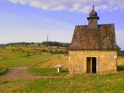
Koskowa Góra (874 m n.p.m., według niektórych źródeł 866 m n.p.m.) – szczyt w Beskidzie Makowskim, położony na północny wschód od Makowa Podhalańskiego, we wsi Bogdanówka. Stanowi kulminację Pasma Koskowej Góry. Na szczycie góry umiejscowiony jest przemiennik krótkofalarski na pasmo 2m /70 cm (SR9P/SR9PC). W pobliżu Parkingu stoi murowana kapliczka, ufundowana ok. 1910 roku przez Jana Koska. Jest pokryta gontem, wewnątrz znajduje się figura Chrystusa upadającego pod krzyżem po raz trzeci z nazwiskiem fundatora.
[EN]
Koskowa Mountain (874 m above sea level, according to some sources, 866 m above sea level) - the peak in the Beskid Makowski, located northeast of Makow Podhalanski, in the village Bogdanówka. Bandwidth is the culmination of Koskowa Mountains. At thetop of the mountain is located on the drive Amateur band 2m / 70 cm (SR9P/SR9PC). Near the Parking stands a stone chapel, founded around 1910 by John Kosek. It is covered with shingles, inside there is a figure of Christ falls beneath the cross for the third time with the name of the founder.
Skrzynka
[PL]
Pudełko 0,6 l umieszczone pod współrzędnymi. W środku kilka przedmiotów + logbook
[EN]
Box 0.6 l located at coordinates. In the middle of several items + logbook
Jak dotrzeć
[PL]
Samochód można zostawić pod wspólrzędnym z waypoint Parking. Dojazd samochodem jest możliwy od wiosny do jesieni, zimą pozostaje wejście od wsi Bogadanówki pieszo. Spod parkingu należy kierować się drogą w kierunku przekaźnika, współrzędne kierują pod samą skrzynkę.
[EN]
Leave your car at the coordinates of the waypoint Parking. Arrival by car is possible from spring to autumn, winter is the entrance of the village Bogadanówki foot. From the parking lot should be guided by the direction of the relay, the coordinates of thesame direct box.
Miłej zabawy / Have fun
 Additional waypoints
| Symbol | Type | Coordinates | Description |
|---|---|---|---|

|
Parking area | --- | Dojazd samochodem dostępny gdy nie ma śniegu / By car available when there is no snow |
 Additional hints
 Pictures

 Log entries:
18x
2x
0x
Log entries:
18x
2x
0x


